The Plot

Discussions about the history of the ship, technical details, etc.

Moderator: Bill Jurens

User avatar
Alberto Virtuani
Senior Member
Posts: 3605
Joined: Mon Jul 08, 2013 8:22 am
Location: Milan (Italy)

Re: The Plot

Post by Alberto Virtuani »

Hi Duncan,
it's exactly what I did. Pinchin draw the 2 parallels (63°N and 64°N), so I'm using exactly his scale in a (very high definition, as you see) copy of the Plot.
IMAGE$40124CFC758B0E63.jpg
IMAGE$40124CFC758B0E63.jpg (38.3 KiB) Viewed 649 times
Or perhaps this is another error in Pinchin's Plot.......... who knows....... :shock:

Bye, Alberto
Last edited by Alberto Virtuani on Wed Sep 30, 2015 9:32 pm, edited 1 time in total.
"It takes three years to build a ship; it takes three centuries to build a tradition" (Adm.A.B.Cunningham)

"There's always a danger running in the enemy at close range" (Adm.W.F.Wake-Walker)
dunmunro
Senior Member
Posts: 4394
Joined: Sat Oct 22, 2005 1:25 am
Location: Langley BC Canada

Re: The Plot

Post by dunmunro »

Alberto Virtuani wrote:Hi Duncan,
it's exactly what I did. Pinchin draw the 2 parallels (63°N and 64°N), so I'm using exactly his scale in a (very high definition) copy of the Plot.

Or perhaps this is another error of Pinchin's Plot.......... who knows....... :shock:

Bye, Alberto
How was the copy made?

In any event, Pinchin provided a scale and he clearly intended that scale to be used.
User avatar
Alberto Virtuani
Senior Member
Posts: 3605
Joined: Mon Jul 08, 2013 8:22 am
Location: Milan (Italy)

Re: The Plot

Post by Alberto Virtuani »

Hi Duncan,
from the very original of course.....(you can download my above map and measure yourself) :wink:
Are you using a high resolution "Plot" copy ? Else, your measurement cannot be very precise.

Bye, Alberto
"It takes three years to build a ship; it takes three centuries to build a tradition" (Adm.A.B.Cunningham)

"There's always a danger running in the enemy at close range" (Adm.W.F.Wake-Walker)
dunmunro
Senior Member
Posts: 4394
Joined: Sat Oct 22, 2005 1:25 am
Location: Langley BC Canada

Re: The Plot

Post by dunmunro »

Alberto Virtuani wrote:Hi Duncan,
from the very original of course.....(you can download my above map and measure yourself) :wink:
Are you using a high resolution "Plot" copy ? Else, your measurement cannot be very precise.

Bye, Alberto
How was the copy made? With a camera?

Your map fragment doesn't include the scale or the latitude marks.
User avatar
Antonio Bonomi
Senior Member
Posts: 3799
Joined: Mon Oct 18, 2004 10:44 am
Location: Vimercate ( Milano ) - Italy

Re: The Plot

Post by Antonio Bonomi »

Hello everybody,

@ Dunmunro,

here your reference with the latitude marks so you can measure and verify the scale being correct.

http://hmshood.com/history/denmarkstrait/S&Nplot.gif

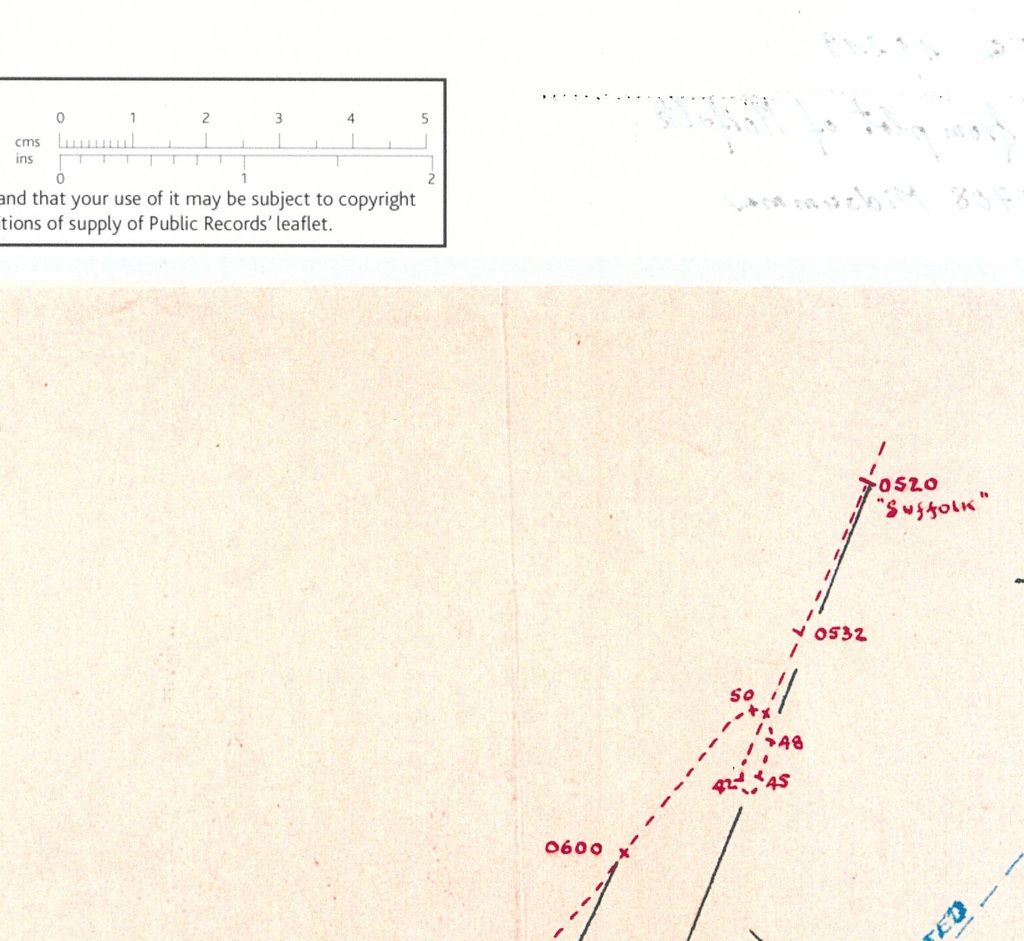
The portion of " The Plot " we are looking at shows from 05.20 until 06.00 a distance/speed of :

1 ) from 05.20 until 05.42 sailing 8,8 sea miles at average 24 knots
2 ) from 05.42 until 05.50 sailing 3,2 sea miles at average 23 knots during the circle
3 ) from 05.50 until 06.00 sailing 5,0 sea miles at average 30 knots

Since mathematic is not an opinion I think we all agree about the fact that those are : 8,8+3,2+5= 17 sea miles

Herr Nilsson has been anticipating me providing you the requested ( by Wadinga ) average speed sailed by Suffolk recorded into her own war diary.
In the timeframe 05.00-06.00 the Suffolk sailed 27,5 sea miles on the water according to her own war diary and let us assume here now that it is correct and not subject to data alteration.

It does not take a genius to realize that 27,5 minus 17 = 10,5 sea miles that are left and must have been sailed by Suffolk on the timeframe 05.00 until 05.20, they are not showed into " The Plot ", but they belong anyhow to the overall Strategical plot scenario.

Question now : what is the speed that enabled Suffolk to sail 10,5 sea miles on 20 minutes ?
Easy answer : more than 31 knots :shock:

So, summarizing, Pinchin with " The Plot " is telling us that Suffolk sailed for 20 minutes at more than 31 knots until 05.20, ... than for 22 minutes at 24 knots only, ... made a circle at 23 knots, ... and than sailed last 10 minutes at 30 knots.


Bye Antonio :D
In order to honor a soldier, we have to tell the truth about what happened over there. The whole, hard, cold truth. And until we do that, we dishonor her and every soldier who died, who gave their life for their country. ( Courage Under Fire )
dunmunro
Senior Member
Posts: 4394
Joined: Sat Oct 22, 2005 1:25 am
Location: Langley BC Canada

Re: The Plot

Post by dunmunro »

Antonio Bonomi wrote:Hello everybody,

@ Dunmunro,

here your reference with the latitude marks so you can measure and verify the scale being correct.

http://hmshood.com/history/denmarkstrait/S&Nplot.gif
You can also use the longitude marks to get the scale and you'll note that it agrees with the scale marked on the map.
User avatar
Herr Nilsson
Senior Member
Posts: 1585
Joined: Thu Oct 21, 2004 11:19 am
Location: Germany

Re: The Plot

Post by Herr Nilsson »

Hello Duncan,

here's a better copy.

Image
Regards

Marc

"Thank God we blow up and sink more easily." (unknown officer from HMS Norfolk)
User avatar
Alberto Virtuani
Senior Member
Posts: 3605
Joined: Mon Jul 08, 2013 8:22 am
Location: Milan (Italy)

Re: The Plot

Post by Alberto Virtuani »

Hello everybody,
@Herr Nilsson:
hi Marc, thanks for posting this very precise and useful map, with the cm and the inches in the ruler. :clap:

@Dunmunro:
hi Duncan,
the map posted by Marc is almost perfectly in synch with my map and calculation, just using a simple ruler, knowing Pinchin scale. I don't know which is problem with your map, perhaps the usage of a wrong parallel lenght between meridians....

Distance traveled by Suffolk from 5:20 to 5:42 is 8,8 sm in 22 mins --> average speed 24 knots (as I said and not 9,35sm at 25,5 knots as you calculated on your map).
Distance traveled by Suffolk from 5:50 to 6:00 is 5,1 sm in 10 mins ---> 30,6 knots after a 360° turn that surely reduced her speed at 5:50 (against 30 knots I was previously evaluating that was already a bit too much). :shock:

However, if we use your map (same proportion) between 5:50 and 6:00 you have 5,41 sm ( 5,41 = 5,1 * 9,35 / 8,8) in 10 minutes, that is 32,5 knots after a 360° turn..... :shock: :shock:

The above just again demonstrates that Pinchin did not even care to respect tactically reasonable and physically credible speeds, in addition to leaving bearings in the middle of the sea (D6 and D7) and moving the turn to north before the battle, according to the "official report" of Ellis (of course Ellis autobiography categorically denies this turn and the "official report", stating precisely the distance at Hood's open fire, around 18000 yards, and the reasons why he decided not to open fire himself).

At the end, "The Plot" is simply wrong (even for the part concerning JUST the CS1 ships for which surely he had available ALL information, thus leaving just 2 options: 1) intentional modifications of the truth, 2) incompetence of Pinchin.....) and this is the only possible conclusion, that I hope everybody now share in this forum. :wink:


Now (again I'm afraid) to all of you to answer Antonio questions below , proposing a different scenario than the one he has reconstructed, or to confirm his one as the best possible reconstruction as per today, according with all available evidences (including the perfect match of bearings and distances in F.O.Busch account at 5:30, Capt. Ellis autobiography. etc.)......

If someone wants to use a different starting point at 4:47 (as Sean was "trying" to propose), please we would like to see his reconstruction of course and speed of Suffolk, matching the available bearings and accounts, not just a statement like "15 sm were possibly 20 sm)...... :negative:
Antonio Bonomi wrote: "You have to consider the interval 04.47 until 05.41 = 54 minutes.
We have in this interval 13 minutes that belongs to Suffolk war diary average speed between 04.00 and 05.00 and other 41 minutes that belongs in the average speed between 05.00 and 06.00 on Suffolk war diary : 13+41 = 54 minutes.

The 22 knots is the average speed enabling Suffolk to start from 15 sea miles at 04.47 with enemy on bearing 184°, ... and after 54 minutes, ... having sailed just around only 20 sea miles ( 22 divided by 60 minutes and multiplied by 54 minutes = around 20 sea miles ) ... :shock: ... be where Ltnt Cdr S.H. Pinchin traced her on " The Plot " , ... so at 17 sea miles from the enemy position at 05.41.

You can try and choose between : ( 22/60 ) x 54 = 19,8 sea miles or ( 22,5/60 ) x 54 = 20,25 sea miles

On the map I attach here under, since you apparently do not understand what I mean, you have the points A,B, C and D on the BLUE line I traced, that are the 20 sea miles sailed at average 22 knots, from 04.47 until 05.41, that you sustain Suffolk sailed on the interval in order to be able to say that the " The Plot " is a correct map.
Plot_evaluation_versus_reality_03.jpg
Plot_evaluation_versus_reality_03.jpg (57.67 KiB) Viewed 589 times
You only have 2 possibilities now :

1) Either you say that this is what you think really happened, like apparently your are stating, keep on writing " The Plot " by Pinchin being a correct map.

2) Or you admit that " The Plot " is an incorrect map as far as Suffolk track relatively to the distance between Suffolk and the enemy at 05.41, being IMPOSSIBLE for the Suffolk to have sailed ONLY the 20 sea miles that using PInchin reference she would have sailed from 04.47 until 05.41, so during those 54 minutes we are evaluating now.

It is a very easy to realize and direct question.

Now I like your and Duncan answer about this question, please."
"
Bye, Alberto
Last edited by Alberto Virtuani on Thu Oct 01, 2015 10:24 am, edited 6 times in total.
"It takes three years to build a ship; it takes three centuries to build a tradition" (Adm.A.B.Cunningham)

"There's always a danger running in the enemy at close range" (Adm.W.F.Wake-Walker)
dunmunro
Senior Member
Posts: 4394
Joined: Sat Oct 22, 2005 1:25 am
Location: Langley BC Canada

Re: The Plot

Post by dunmunro »

Herr Nilsson wrote:Hello Duncan,

here's a better copy.
Thanks. However, this fragment doesn't have Pinchin's scale on it. The scale on the edge of the image appears to be a digital overlay, which may not be accurate.
User avatar
Herr Nilsson
Senior Member
Posts: 1585
Joined: Thu Oct 21, 2004 11:19 am
Location: Germany

Re: The Plot

Post by Herr Nilsson »

@Duncan

Pinchin had no scale as a ruler at all. His scale was in the legend (1'' to 5 miles). I'm confident in the abilites of the PRO personnel in making copies.
Regards

Marc

"Thank God we blow up and sink more easily." (unknown officer from HMS Norfolk)
dunmunro
Senior Member
Posts: 4394
Joined: Sat Oct 22, 2005 1:25 am
Location: Langley BC Canada

Re: The Plot

Post by dunmunro »

Herr Nilsson wrote:@Duncan

Pinchin had no scale at all. His scale was 1'' to 5 miles. I'm confident in the abilites of the PRO personnel in making copies.
Small variations in scale can make a big difference.

If you have the entire map, can you measure the distance in pixels from the markers at 31w 63n to 31w 64n (60nm) and from 31w 63n to 32w 63n (27.26nm) and see if they agree with with the inch scale on the edge of the map?
User avatar
Antonio Bonomi
Senior Member
Posts: 3799
Joined: Mon Oct 18, 2004 10:44 am
Location: Vimercate ( Milano ) - Italy

Re: The Plot

Post by Antonio Bonomi »

Hello everybody,


@ Dunmunro,

you wrote :
If you have the entire map, can you measure the distance in pixels from the markers at 31w 63n to 31w 64n (60nm) and from 31w 63n to 32w 63n (27.26nm) and see if they agree with the inch scale on the edge of the map?
Finally you realized that the only way to have a sure reference, is to have the 60 sea miles of the distance between the 2 parallel markers and divide the distance by 6 to obtain the 10 sea miles reference, ... so the geographical precise reference.

Anyway, just for your information, ... there is more than one copy of " The Plot " in the PRO archive, ... as you may have already realized, ... and of course I have ALL of them ... :wink:

Here a low resolution of one of them, ... different than Marc copy :
Plot_0520_0600_02.jpg
Plot_0520_0600_02.jpg (38.21 KiB) Viewed 565 times
Also this one confirms Alberto and Marc maps and my above measurements.

Has anyone tried to provide a logic of those speed changes by Suffolk, especially between 05.20 and 05.42 ?

IMHO it is mandatory that Suffolk must have been at bearing D/6 ( 319° ) at 05.41 from the Norfolk position.

Bye Antonio :D
In order to honor a soldier, we have to tell the truth about what happened over there. The whole, hard, cold truth. And until we do that, we dishonor her and every soldier who died, who gave their life for their country. ( Courage Under Fire )
User avatar
Herr Nilsson
Senior Member
Posts: 1585
Joined: Thu Oct 21, 2004 11:19 am
Location: Germany

Re: The Plot

Post by Herr Nilsson »

D/6 or D/8?
Regards

Marc

"Thank God we blow up and sink more easily." (unknown officer from HMS Norfolk)
User avatar
Antonio Bonomi
Senior Member
Posts: 3799
Joined: Mon Oct 18, 2004 10:44 am
Location: Vimercate ( Milano ) - Italy

Re: The Plot

Post by Antonio Bonomi »

Hello everybody,

@ Herr Nilsson,

well, ... D/6, ... or D/8, ... or D/C, ... it is so badly written on my copies, ... that it is difficult to realize it well.

If you have a sure answer, ... please go ahead and tell us ... :wink:

What I do care is the fact that the bearing is the correct one between HMS Norfolk and HMS Suffolk at 05.41, ... and it is between 318° and 320° depending on the maps ( at least 3 ) where you read it.

Also in this case I accept any input and opinion about the correct precise bearing ... but it is within that range.

Bye Antonio :D
In order to honor a soldier, we have to tell the truth about what happened over there. The whole, hard, cold truth. And until we do that, we dishonor her and every soldier who died, who gave their life for their country. ( Courage Under Fire )
User avatar
Herr Nilsson
Senior Member
Posts: 1585
Joined: Thu Oct 21, 2004 11:19 am
Location: Germany

Re: The Plot

Post by Herr Nilsson »

I was wondering if it's D/7 and D/8 or D/F and D/e. The 7s on the plot usually don't have a line in the middle.
Regards

Marc

"Thank God we blow up and sink more easily." (unknown officer from HMS Norfolk)
Post Reply