The Plot

Discussions about the history of the ship, technical details, etc.

Moderator: Bill Jurens

User avatar
Antonio Bonomi
Senior Member
Posts: 3799
Joined: Mon Oct 18, 2004 10:44 am
Location: Vimercate ( Milano ) - Italy

Re: The Plot

Post by Antonio Bonomi »

Hello everybody,

@ Dunmunro,

you wrote :
If you think about it, a ship steaming on a course of 270° cannot hold a bearing of 270° on a ship steaming nearly perpendicular to her course for more than a fraction of a minute (or seconds if we use a fixed point rather than the entire target ship).

The odds of Norfolk having bearings of EXACTLY 270° to Bismarck and EXACTLY 230° to Hood are vanishingly small. Both these numbers had to be mere approximations.
Duncan, I have no problems to agree and accept the fact that those references, so 270° to BS and 230° to Hood, have been valid for a very small number of seconds, ... but as I wrote several times, ... I am just using what is available on the official documents, including their approximations.

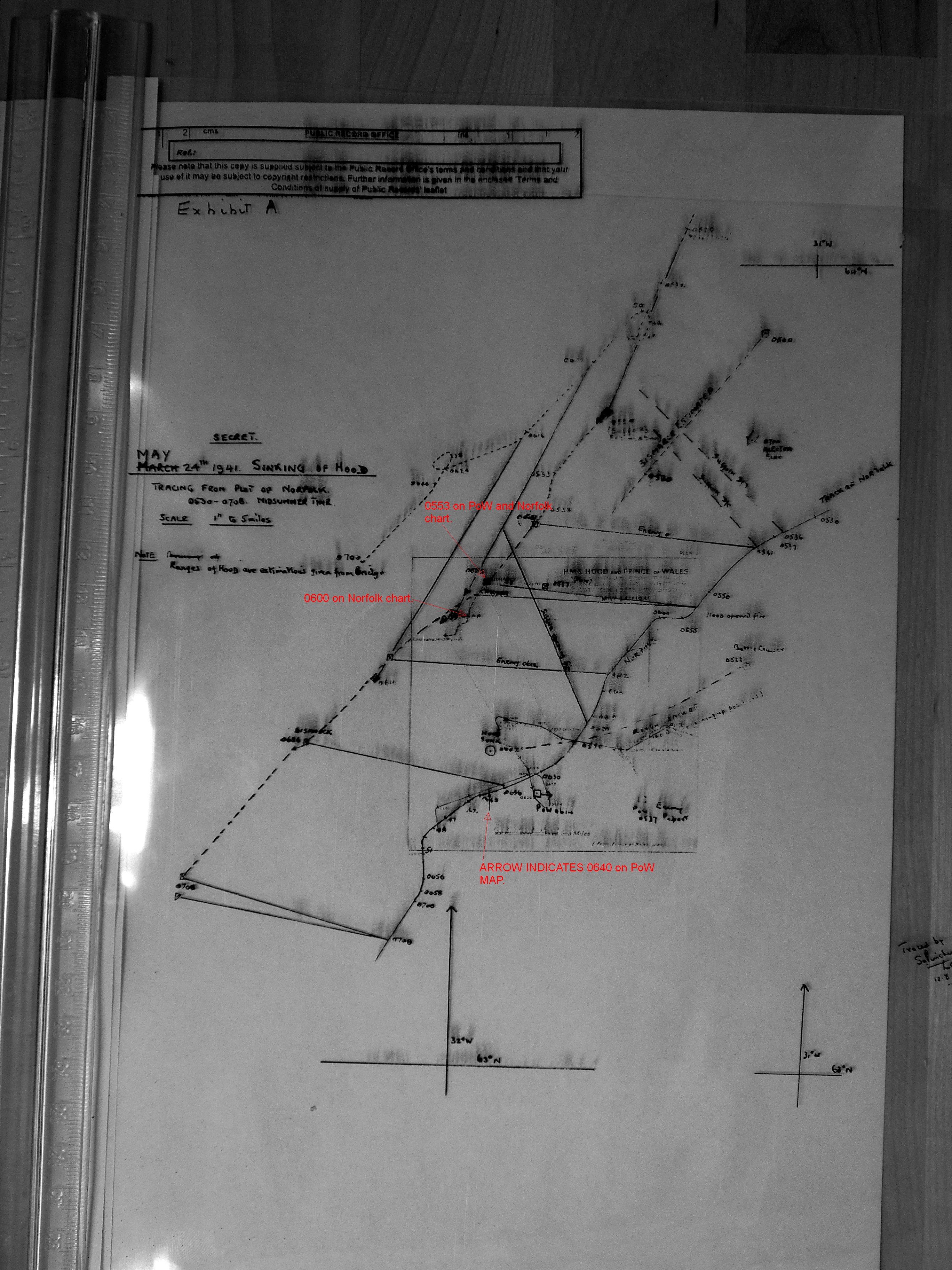
What was important for me was to be able to re-size the battlefield correctly using the available official bearings and place correctly the various warship tracks on it, so Norfolk, Suffolk, BC1 ( Hood+PoW -> using the correct Rowell one ) and the Germans ( BS+PG -> from 05.41 until 06.00 with a straight 220° line ref. PG battle map ).

In this way as I did " The Plot " itself shows how it should have been done originally on August 1941, because we are having cross bearings among all the tracks and from all angles, so no possibility to make any battlefield enlargement error.

Than one need to adjust the single tracks if more details about them are available.

But on that revisited map the main warship tracks now are " frozen" by those 6 bearings no one can dispute since they are officially recorded on other documents too. Every one matches and confirms the other ones ... and I have also a 7th one that is overkilling every doubts in case someone will arise any dispute about my above work :wink: .

On that map the relative distances are now more precise than on other maps and reports available.

Everything with due tolerances of course ... as usual ... :wink:

Bye Antonio :D
In order to honor a soldier, we have to tell the truth about what happened over there. The whole, hard, cold truth. And until we do that, we dishonor her and every soldier who died, who gave their life for their country. ( Courage Under Fire )
User avatar
wadinga
Senior Member
Posts: 2472
Joined: Sat Mar 12, 2005 3:49 pm
Location: Tonbridge England

Re: The Plot

Post by wadinga »

Hello Antonio,

You say
" frozen" by those 6 bearings no one can dispute since they are officially recorded on other documents too.
Let's pop them in the microwave and see if they stay frozen. :cool:

This is incorrect on the 230 and 270 for the reasons Duncan has pointed out. One is on a fast moving target going right to left and the other is on the indeterminate site of Hood's sinking. Where- the original explosion site, the oil fire, some other place? The D6 bearing is not supported by anything since it is self referential to the Suffolk position on the so-called "Norfolk original map" . If it were actually to be a radio bearing its accuracy right/left is nowhere near as high as a visual bearing. Maybe plus or minus 10 degrees. Unfortunately Alberto has not yet asked you about the so-called "Norfolk original map" creation date.There is nothing original about it is there?

Also you have erased the southern part of the Norfolk track where we actually have a reliable bearing and distance pair at 06:34. PoW is 1.5 miles directly astern of Norfolk at his point. All other bearings are of lower reliability than this. This ties together Pinchin's plot and Rowell's.

You have also left out the 220 bearing Norfolk to PoW which because it was done at a low stress, non-turning time is more likely to be accurate than any of your other bearings.

All the best

wadinga
"There seems to be something wrong with our bloody ships today!"
User avatar
Antonio Bonomi
Senior Member
Posts: 3799
Joined: Mon Oct 18, 2004 10:44 am
Location: Vimercate ( Milano ) - Italy

Re: The Plot

Post by Antonio Bonomi »

Hello everybody,

@ Wadinga,

come on Sean, ... this is becoming ridiculous from your side, ... some time ago the only bearing you trusted was the 335° at 06.20 one when RearAdm W.F. Wake-Walker saw the Suffolk firing, ... and just that one alone is sufficient to re-align correctly the 2 tracks of Norfolk and Suffolk, ... as originally drew by Pinchin ... and the D/6 will magically go on his proper position ... and on this way the battlefield is reduced the way it should have been since August 1941.

You cannot touch neither the 230° at 06.00 declared by WW himself, nor the 270° at 06.00 since it is supported by the other bearings taken soon before and after from Norfolk to Prinz Eugen and Bismarck.

Than of course we can correct the single tracks making them more precise and the 220° at 05.50 will be there too.

As simple as that. This hopefully will end the debate about " The Plot " being correctly re-aligned now.

But I want to make you another gift ... to overkill it ... the 7th bearing from Suffolk to PoW at 05.53, at open fire :
0553 (B). Heavy gun flashes bearing 185°.
On the original of " The Plot " is of course NOT there.
Obviously it is perfectly there on my re-designed and corrected map ... :wink:

Closing this discussion hopefully for good, ... I leave you with the original Marc ( Herr Nilsson ) question :
Who was Lt.Cdr. Sidney Hugh Pinchin ?
Maybe we need to dig a bit deeper on this guy real duty on HMS Norfolk that day ... and after ... :wink:

Enjoy ...

Bye Antonio :D
In order to honor a soldier, we have to tell the truth about what happened over there. The whole, hard, cold truth. And until we do that, we dishonor her and every soldier who died, who gave their life for their country. ( Courage Under Fire )
dunmunro
Senior Member
Posts: 4394
Joined: Sat Oct 22, 2005 1:25 am
Location: Langley BC Canada

Re: The Plot

Post by dunmunro »

Antonio Bonomi wrote:Hello everybody,

@ Wadinga,

come on Sean, ... this is becoming ridiculous from your side, ... some time ago the only bearing you trusted was the 335° at 06.20 one when RearAdm W.F. Wake-Walker saw the Suffolk firing, ... and just that one alone is sufficient to re-align correctly the 2 tracks of Norfolk and Suffolk, ... as originally drew by Pinchin ... and the D/6 will magically go on his proper position ... and on this way the battlefield is reduced the way it should have been since August 1941.

You cannot touch neither the 230° at 06.00 declared by WW himself, nor the 270° at 06.00 since it is supported by the other bearings taken soon before and after from Norfolk to Prinz Eugen and Bismarck.

Than of course we can correct the single tracks making them more precise and the 220° at 05.50 will be there too.

As simple as that. This hopefully will end the debate about " The Plot " being correctly re-aligned now.

But I want to make you another gift ... to overkill it ... the 7th bearing from Suffolk to PoW at 05.53, at open fire :
0553 (B). Heavy gun flashes bearing 185°.
On the original of " The Plot " is of course NOT there.
Obviously it is perfectly there on my re-designed and corrected map ... :wink:

Closing this discussion hopefully for good, ... I leave you with the original Marc ( Herr Nilsson ) question :
Who was Lt.Cdr. Sidney Hugh Pinchin ?
Maybe we need to dig a bit deeper on this guy real duty on HMS Norfolk that day ... and after ... :wink:

Enjoy ...

Bye Antonio :D
Any bearing that ends in zero or five is an approximation.
dunmunro
Senior Member
Posts: 4394
Joined: Sat Oct 22, 2005 1:25 am
Location: Langley BC Canada

Re: The Plot

Post by dunmunro »

I made digital copies of the Pinchin and PoW plots, then carefully resized them so that both had exactly the same scale:

Image

I then printed them on transparency material and overlaid them. As you can see, my laser printer didn't like doing this and there is some smudging.

You can see that there is very good agreement between these two plots and that, in general, they conform to W-W's contentions that the range from Norfolk to Hood was nearer to 15nm than 10, and that the range from Norfolk to Bismarck was approximately 13-14nm at 0600. and again this agrees well with Norfolk's ranges to Bismarck as recorded by her GO. You will also note that there's just no way to squeeze Norfolk to 10 or 11nm to Bismarck and have the two charts come anywhere near alignment.


direct link: http://www.sfu.ca/~dmunro/images/WW_poW_overlay.jpg
User avatar
Antonio Bonomi
Senior Member
Posts: 3799
Joined: Mon Oct 18, 2004 10:44 am
Location: Vimercate ( Milano ) - Italy

Re: The Plot

Post by Antonio Bonomi »

Hello everybody,

@ Dunmunro,

respectful of your work and admiring your initiative, were you trying to do this :

Dunmunro_trial_02.jpg
(213.21 KiB) Not downloaded yet
Dunmunro_trial_03.jpg
Dunmunro_trial_03.jpg (44.48 KiB) Viewed 3995 times

So using the incorrect " The Plot " and Plan 4 ... why ???

Bye Antonio :D
In order to honor a soldier, we have to tell the truth about what happened over there. The whole, hard, cold truth. And until we do that, we dishonor her and every soldier who died, who gave their life for their country. ( Courage Under Fire )
dunmunro
Senior Member
Posts: 4394
Joined: Sat Oct 22, 2005 1:25 am
Location: Langley BC Canada

Re: The Plot

Post by dunmunro »

Antonio Bonomi wrote:Hello everybody,

@ Dunmunro,

respectful of your work and admiring your initiative, were you trying to do this :


So using the incorrect " The Plot " and Plan 4 ... why ???

Bye Antonio :D
I have access to plan 4 and I don't think "the plot" is incorrect. I wanted to independently recreate an overlay.
User avatar
Antonio Bonomi
Senior Member
Posts: 3799
Joined: Mon Oct 18, 2004 10:44 am
Location: Vimercate ( Milano ) - Italy

Re: The Plot

Post by Antonio Bonomi »

Hello everybody,

@ Dunmunro,

you wrote :
I have access to plan 4 and I don't think " The Plot" is incorrect.
Here for you an easy to realize demonstration of " The Plot " being an incorrect traced map originally.
NOTE : I have half dozen more if you are not convinced at the end by this one.

Reference RaerAdm W.F. Wake-Walker report of June 5th, 1941 of seeing Suffolk firing at 06.20, the one Wadinga ( Sean ) liked so much and until few weeks ago thought being the only reliable bearing we had :
... and at 06.20 Suffolk was sighted bearing 335°, a long way off and firing. This was the first time that Suffolk was seen.

ADM116-4352_Exhibit_A.jpg
ADM116-4352_Exhibit_A.jpg (46.35 KiB) Viewed 3963 times
... and here the correct version of it, that could have been easily realized on August 1941 ... just doing more or less what you did above using the Plan 4 and the Rowell map for example, ... plus the already available bearings on the map ... :wink:
Plot_redone_adjusted_bearings_07.jpg
Plot_redone_adjusted_bearings_07.jpg (63.96 KiB) Viewed 3963 times
An elementary exercise, having the correct data and tracing them on the proper way ... :wink:

Bye Antonio :D
In order to honor a soldier, we have to tell the truth about what happened over there. The whole, hard, cold truth. And until we do that, we dishonor her and every soldier who died, who gave their life for their country. ( Courage Under Fire )
Guest

Re: The Plot

Post by Guest »

Dear all,
I would firstly like to commend Mr Bonomi for his attempts to create a more acurate plot of the battle, which is a most difficult process to carry out and deserves a lot of credit for attempting to do so. If I may say all contributors have a vast knowledge and shows that the memory of those involved in the battle are not forgotten. I would like to thank the Moderators for allowing me to post my small contributions which I hope may be of help. In the National Archives there are 45 documents relating to the Hood inquiry in MFQ 1/219 one of which is the plot created by Pinchin and designed to give the 2nd board a chance to remedy the findings of the 1st. However there are many issues to consider before attempting an estimated reconstruction;
1. The inaccurate nature of the plot itself. The relative tracks of Norfolk and Suffolk appear to have been estimated using their positions in relation to their obsevations of the BS and PG (The green and blue dotted lines). We can see the lines of the D/F bearings obtained on Suffolk by Norfolk at 0536 and 0541 do not correlate to the times on the Suffolk track (Tactical diagrams V VI VII). We can also see Suffolks positional error by her estimated plot position for PoW's enemy report at 0537 (Blue square to one side of where the lines of Norfolks observation of Suffolk's opening fire and Norfolks enemy positions at 0552) as opposed to Norfolk's (Red square in line with the position of PoW at 0614 with arrow attached). So in essance the plot itself is only useful to guage the movements of Norfolk & Suffolk during the battle. The plot for PoW also has errors,(Admitted by Rowell) the straight line in her course after 0634 is at odds with her ships log (ADM 53/114888) which states that at 0642 she heads back toward BS and PG on a course of 278 degrees until at 0649 she runs on 220 degrees and at 0653 turns to fall into line with Norfolk on a course of 140 degrees and then 160 degrees at 0700. Norfolk's (ADM 53/114810) and PoW's logs show that (0640 for Norfolk and 0634 for PoW) the PoW was well on the stb side of Norfolk.
2. Miscalculated positions, Suffolk had the largest DR errors (As far as we know) and had to make three seperate plot adjustments resulting in a shift of a total of approx 41 miles. If it is resonable to assume that if the Suffolk had errors then the Pow, Norfolk and even the Hood also had DR errors. This means that not only Suffolk's position on the plot may be incorrect, but Norfolk's as well.
3. Times, we know that the accuracy of the timing of events of the battle are only relative to the accuracy of the watch of the person observing (Even on the same ship!) for example, Paymaster Commander Bailey on Norfolk recorded the battle for a narrative of the action and notes that Hood opened fire at 0553, she was on fire form PG at 0555, and exploded at 0559. Lieutenant Commander Hunter-Terry on PoW obseving in the after HA director notes that Hood opened fire at 0552, she was on fire from PG at 0557, and exploded at 0600. Capt Leach noted the times as, Hood opens fire at 0552.30, Hood on fire before 2 Blue turn at 0555, and exploded at 0600. Capt Ellis states that Hood exploded at 0559. This is without mention of the German time differences, therefore an attempt at correlating these times will affect positions and the plot immensely.
4. Errors in bearings and ranges, bearing will be 'reasonably' accurate despite atmospheric considerations, but we still have to have a plus or minus either side of these bearings due to errors. Ranges however are different and errors are a common occurance (Hence obtaining a number of 'cuts') and occur due to weather, operator fatigue or error, and rangefinder error (Numerous).
5. Finally, would it be wise to use the approximate final resting place position published by the Mearns expedition as a start. Mearns found Hood from her last Enemy Report position and began a search from there resulting in her discovery. If a rough estimate could be established of her drift and movement due to surface and deep water currents during her sinking, perhaps a circle could be drawn from a central spot that would, in relation to her last course give a very aprroximate position of her sinking and a plot from there could be attempted. However even today with sophisticated methods of computation, it would only be an estimation (Our sympathy should go to poor Pinchin in 1941!) but it does seem a possible place to start?
Thank you all once again for all your efforts and for allowing my contribution,
Cag.
User avatar
Antonio Bonomi
Senior Member
Posts: 3799
Joined: Mon Oct 18, 2004 10:44 am
Location: Vimercate ( Milano ) - Italy

Re: The Plot

Post by Antonio Bonomi »

Hello everybody,

@ CAG,

first of all many thanks for your compliments and fairness, I have read your post with great pleasure.
Second it is my turn to congratulate you for your showed competence on the PRO Kew archive as well as the balanced way to read the content of all the documents you have listed above.

I would agree on all your evaluations but I like to underline the fact that one thing are the plots and maps available on the various documents, where all you above consideration do apply, another thing is “ The Plot “ by Pinchin, that was done for one reason only, just to provide a reference to RearAdm Wake-Walker to change from 20.000 yards to 30.000 yards the HMS Norfolk distance from HMS Hood, and consequently from the enemy.
In fact it was used at the Hood Second board ( Walker ) by Wake-Walker to change is previously declared and signed Norfolk distance at the Hood First board ( Blake ), and I will not list again all the many errors contained on it that enabled the realization of what LtntCdr S.H. Pinchin needed to trace on that plot to show Norfolk at 15 sea miles from Hood at 06.00.

Having realized this, one should easily understand that “ The Plot “ is useless and misleading to realize the whole scenario, while on the other way around after having realized a precise enough overall map, one can easily realize how incorrect “ The Plot “ is and why it was made on that way given the information available at that time.

I think that you should move from this thread to the other one about the whole battle approach scenario, so all your competences and analysis can be utilized to provide value add on the realization of a more precise map using mainly the bearings available on the many documents you listed, not only British but also German.

This one :
viewtopic.php?f=1&t=6323

You last point ( 5 ) deserve a special comment, since I am using as main references the DR positions of Suffolk and Norfolk at 20.00 from their own war diaries as a starting point, … to end up with Commander Warrand 05.43 radio position provided with the Hood enemy interception report just before the battle ( the one used by David Mearns to find the Hood wreck ), to realize the overall map.
I think those are the most accurate inputs we have to make the map I want to realize, but I can change in case somebody has a better and more precise input than those 2 to be used as main reference.

Last thing I am curious to see your Suffolk Tactical diagrams V, VI, VII, … maybe I have them, … maybe not, … since I have realized that many times they moved maps on different documents.

Ciao Antonio :D
In order to honor a soldier, we have to tell the truth about what happened over there. The whole, hard, cold truth. And until we do that, we dishonor her and every soldier who died, who gave their life for their country. ( Courage Under Fire )
Guest

Re: The Plot

Post by Guest »

Hi all,
Thank you Mr Bonomi for your kind words (I think it more respectfull to call you Mr Bonomi than Antonio), I do always attempt to keep an open mind but do struggle with the conspiracy theory reason but I suppose that is due to my uncle having served aboard PoW and his respect for his Captain, but more learned people than myself should debate that! (Yourself included). Unfortunately I have not been able to track down Suffolk's tracks as yet as ASAIK they were forwarded on by Admiralty Home Fleet orders. I think (I'm trying to find out for certain) that Capt Ellis left an autobiography at the Churchill Archives of his career inc the Battle which may be of use to you all?
Than you all again for allowing me to read and contribute,
Cag.
User avatar
Alberto Virtuani
Senior Member
Posts: 3605
Joined: Mon Jul 08, 2013 8:22 am
Location: Milan (Italy)

Re: The Plot

Post by Alberto Virtuani »

Hi,
many thanks for your suggestion. I was already aware of the Ellis authobiografy and I have requested to the Churchill archives the book chapter and all the reports (included in Ellis available documents at the same Churchill Archives) related to the Bismarck episode, to see whether they confirm the Suffolk official reports.

Bye, Alberto
"It takes three years to build a ship; it takes three centuries to build a tradition" (Adm.A.B.Cunningham)

"There's always a danger running in the enemy at close range" (Adm.W.F.Wake-Walker)
User avatar
Antonio Bonomi
Senior Member
Posts: 3799
Joined: Mon Oct 18, 2004 10:44 am
Location: Vimercate ( Milano ) - Italy

Re: The Plot

Post by Antonio Bonomi »

Hello everybody,

@ CAG,

you can call me either Mr. Bonomi or Antonio, ... I will not be offended in any case, ... everybody calls me Antonio here in, ... but I leave the choice to you.

It is since some time that someone called it a " conspiracy " theory, ... but on this whole events nobody wanted to make a conspiracy against someone or his own country.

This was a pure war propaganda need, ... so in theory the opposite of a " conspiracy ".
It was done for a positive ( war need ) interest, for the National war needs on June 1941, so in theory with a very positive intent.

You raised a very important point referencing to the HMS Suffolk Tactical plots and Capt Ellis documents ... which I am sure will provide a lot of additional light on this matter.

Problem is that the Tactical plots have been taken by RearAdm W.F. Wake-Walker ( CS 1) and Adm Tovey ( Home Fleet ) as you can read yourself.
Ellis_to_WW_11_June_1941.jpg
Ellis_to_WW_11_June_1941.jpg (84.7 KiB) Viewed 3568 times
Now it will be hard to find them ... :think:

Lets see what Capt Ellis autobiography at the Churchill Archives will provide us now ... :think:

Bye Antonio :D
In order to honor a soldier, we have to tell the truth about what happened over there. The whole, hard, cold truth. And until we do that, we dishonor her and every soldier who died, who gave their life for their country. ( Courage Under Fire )
User avatar
wadinga
Senior Member
Posts: 2472
Joined: Sat Mar 12, 2005 3:49 pm
Location: Tonbridge England

Re: The Plot

Post by wadinga »

Welcome Cag,

To the Denmark Straits Study Group, where as you may have detected discussions and feelings sometimes run hot. I hope you will choose to register on this site as even your first postings show you have much to contribute.

It is particularly interesting the access you have had to original documentation and I am sure we would all welcome information from these sources.

For instance you say
We can see the lines of the D/F bearings obtained on Suffolk by Norfolk at 0536 and 0541 do not correlate to the times on the Suffolk track (Tactical diagrams V VI VII).


Antonio is in possession of copies of PoW's large scale tactical plots from the PRO that apparently show no indications whatsoever of D/F of Suffolk's bearing from PoW after 03:36 that morning. He has speculated that 05:36 and 05:41 on Pinchin's Plot represent D/F but has presented no corroberation from the PoW log or any other place.

Do you have definite indications that later speculative lines drawn to estimated positions of Suffolk were actually D/F bearings or do you think it likely, as I do, they are merely charting guesswork?

You have very correctly pointed out:
2. Miscalculated positions, Suffolk had the largest DR errors (As far as we know) and had to make three seperate plot adjustments resulting in a shift of a total of approx 41 miles. If it is resonable to assume that if the Suffolk had errors then the Pow, Norfolk and even the Hood also had DR errors. This means that not only Suffolk's position on the plot may be incorrect, but Norfolk's as well.
Antonio is in possession of a copy small scale map made by Suffolk dated 11th June, of which he has shown only the title panel, and the same of a small scale scale map by Norfolk, submitted with Wake-Walker's report, thumbnails of which he has shown. He has been less than forthcoming as to whether these maps represent tracks corrected with the navigational updates (DR errors) identified or not. Do you know? He has recently grudgingly admitted that the German battle group wins the inaccurate navigation competition with 90 miles out which is inconvenient for his "Blame Game". As you rightly say, and has frequently been pointed out, only Hood's wreck provides real world certainty in positioning and everybody else is wrong because of 1941 navigation limitations.

Lack of understanding of these navigational limitations have indeed spawned a gigantic "Conspiracy Theory" in which "Poor Pinchin's" efforts to rationalise the information have been deliberately misconstrued as a cover-up to hide the alleged shameful actions of various British naval officers and their subsequent false testimony to avoid Courts Martial and uphold their decorations. After two years of baseless allegations against the individual reputations of these officers, the emphasis is slowly swinging to some kind of Admiralty propaganda PR coup. However, when subject to scrutiny, every part of the so-called evidence of wrong-doing is exposed for the miasma it is, and I detect you have already identified many of its shortcomings.

Unfortunately there are now several threads running in parallel.

All the best

wadinga
"There seems to be something wrong with our bloody ships today!"
User avatar
Antonio Bonomi
Senior Member
Posts: 3799
Joined: Mon Oct 18, 2004 10:44 am
Location: Vimercate ( Milano ) - Italy

Re: The Plot

Post by Antonio Bonomi »

Hello everybody,

@ Wadinga,

you wrote :
... " Poor Pinchin's " efforts to rationalize the information ...
you must be joking Sean, ... this thread shows the shame of what Pinchin did to save RearAdm Wake-Walker from his own superficial Hood First Board " suicidal " signed declarations ... enlarging the battlefield an inventing an Hood track for the purpose ... and you still write a statement like that.

I realized that you do not like to admit that there was an urgent reason for Wake-Walker for this document to be created the way it has been done, ... but this is the reality.
They " created " it and Wake-Walker went to the Hood Second Board with it to change his previous declarations.
A real shame and you should simply accept it as it is.

I suggest you to read back this thread and focus on your favorite bearing at 06.20 between Norfolk and Suffolk of 335° ... the one declared by Wake-Walker on his official report ... the one you like the most, ... on my April 4, 2015 post and study it.

Than you look at the 2 maps in that post I wrote and apply this Suffolk input to the Pinchin original incorrect plot and to my corrected one below it :
0553 (B). Heavy gun flashes bearing 185°. Half a minute later Bismarck opened fire to port.
Obviously on my corrected version it is perfect, while it is not there on Pinchin plot :
Plot_redone_adjusted_bearings_07.jpg
Plot_redone_adjusted_bearings_07.jpg (67.28 KiB) Viewed 3547 times
But once again you will not admit the reality as it shows, ... and will invent another reason why you are still unable to understand the evidence in front of you ... and will create another reason not to believe ... dementia, tolerances, etc etc etc

You should also measure Suffolk distance from the enemy at 05.41, ... because it is a match of what Prinz Eugen radar measured on that timeframe ... 176 Hundert ( hectometers ) = 17.600 meters = 9,5 sea miles = 19.247 yards ... but I am sure that also in this case you will find out a reason not to believe it.
PG_to_Suffolk_176_Hectometers.jpg
PG_to_Suffolk_176_Hectometers.jpg (21.25 KiB) Viewed 3545 times
Just tell me if you do not like to help us on making the correct Hood and PoW track on the other thread, ...because you know I can do it myself very easily ... :wink:

Lets see how willing you are to find the truth now, ... compared to your willingness to still support at any cost ( :shock: ) the version of those events that has been incorrectly written on last 70 years ... :wink:

Bye Antonio :D
In order to honor a soldier, we have to tell the truth about what happened over there. The whole, hard, cold truth. And until we do that, we dishonor her and every soldier who died, who gave their life for their country. ( Courage Under Fire )
Post Reply