Regards Steve
AltaFjord, KaaFjord and LangFjord
-
Kit-Builder

- Member
- Posts: 86
- Joined: Sun Nov 27, 2005 12:25 pm
- Location: Western Australia
-
Ulrich Rudofsky

- Contributor & Translator
- Posts: 844
- Joined: Sat Oct 16, 2004 9:16 pm
- Location: State of New York
-
Ulrich Rudofsky
- Contributor & Translator
- Posts: 844
- Joined: Sat Oct 16, 2004 9:16 pm
- Location: State of New York


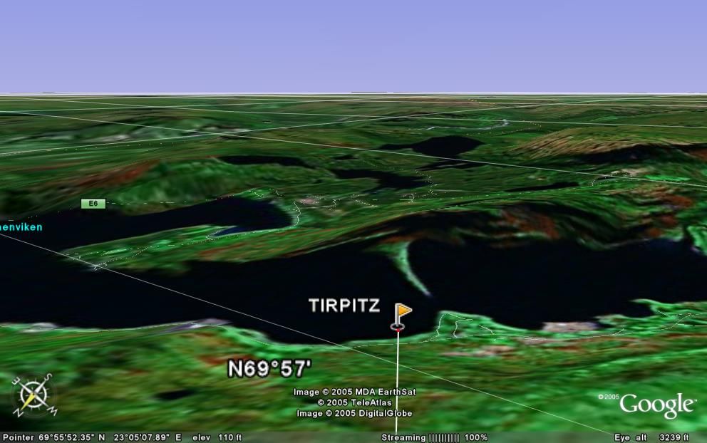
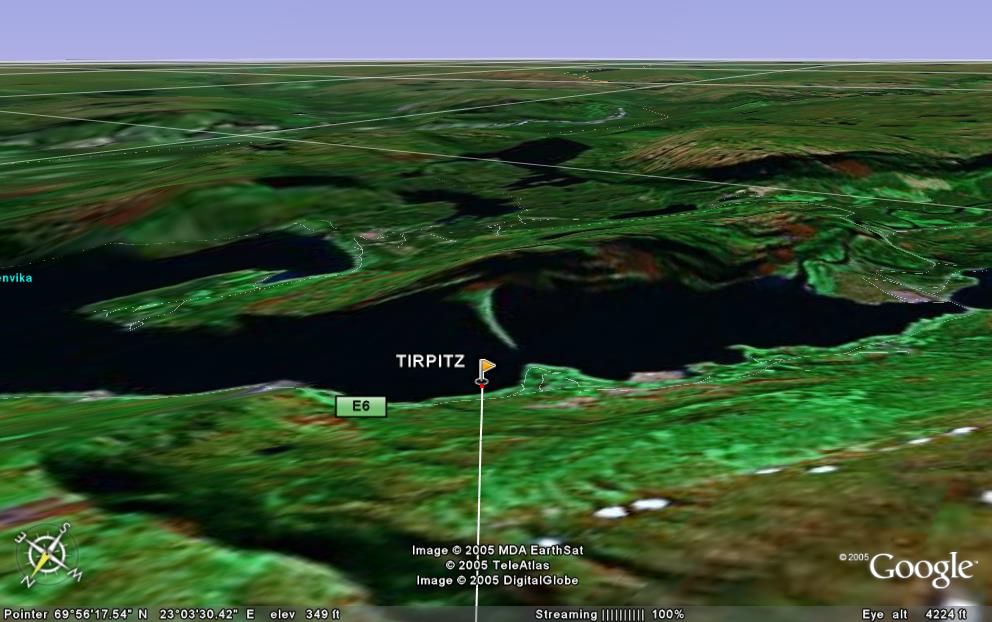
Sometimes I wonder about the altitude from which pictures are taken or what the enlargement represent. Google Earth lets you zoom to certain altitudes and it give you a rough idea. Here is the Kaa Fjord from 5000 and 10000 ft (see lower left corner). It also gives you the altitude of the surrounding mountains and coordinates when you move the cursor and the birds-eye view can be tilted and rotated into a pseudo-flying approach. http://earth.google.com/
Ulrich
-
Antonio Bonomi

- Senior Member
- Posts: 3799
- Joined: Mon Oct 18, 2004 10:44 am
- Location: Vimercate ( Milano ) - Italy
AltaFjord and KaaFjord
Ciao all,
Many thanks for the compliments
Bravo Ulrich, your skill about Google earth is SUPER
The view of the KaaFjord you provide do give a very good idea of the perspective the Royal Navy pilots had on board the Hellcat's, Wildcat's, Corsair's, Barracuda and Lancaster's used to attack Tirpitz in there.
Maybe you can also try to have some more very important historical view of the KaaFjord.
If you can fly with your ' skill ' from the inside of KaaFjord, from Mathisdalen into KaaFjord, .. than you will have the perfect view of the Lancaster attacking lanes.
If you can put your ' eyes ' on Alta downtown, on top of the Alta Church bell tower and than look to the left ,... than you will see exactly how Torsten Raaby ( a Norway underground agent ) was looking at the German ships anchored on KaaFjord or coming out for training into RafsBotn, AltaFjord or LangFjord, .... and taking photos of them to be delivered thru Sweden borders into the British hands, to prepare the attack on Tirpitz.
But the Norway underground agents controlling Tirpitz is another very fascinating story, .. and I think it will require a dedicated post to be explained, ... in the future.
Ciao Antonio
-
Ulrich Rudofsky
- Contributor & Translator
- Posts: 844
- Joined: Sat Oct 16, 2004 9:16 pm
- Location: State of New York
“If you can fly with your ' skill ' from the inside of KaaFjord, from Mathisdalen into KaaFjord, .. than you will have the perfect view of the Lancaster attacking lanes.”
A "pseudo-flight" from Mathisdalen to the "Tirpitz" using Google Earth would look like this (start with the bottom picture). The maps up there in the middle of nowhere have not the details of some sections like New York City and Venice, but it gives you a rough idea. Mathisdalen (Valley) is not even on the map (22.9E/69.85N)! Using it yourself instead of looking at these static pictures is a little more interesting.
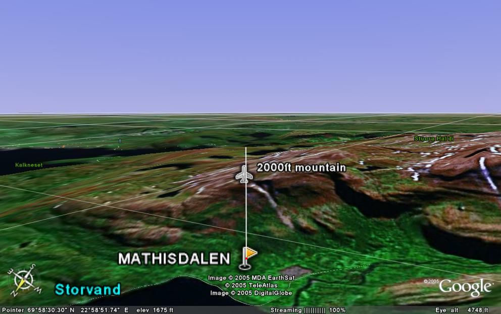
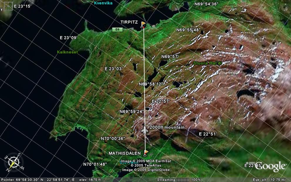
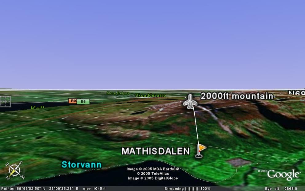
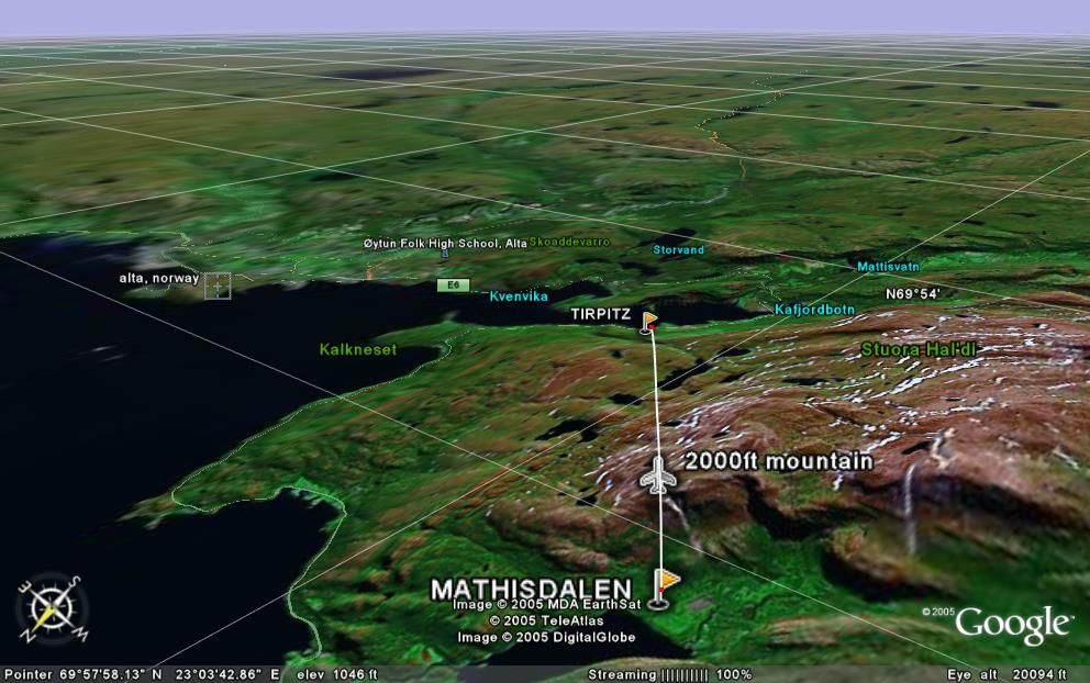
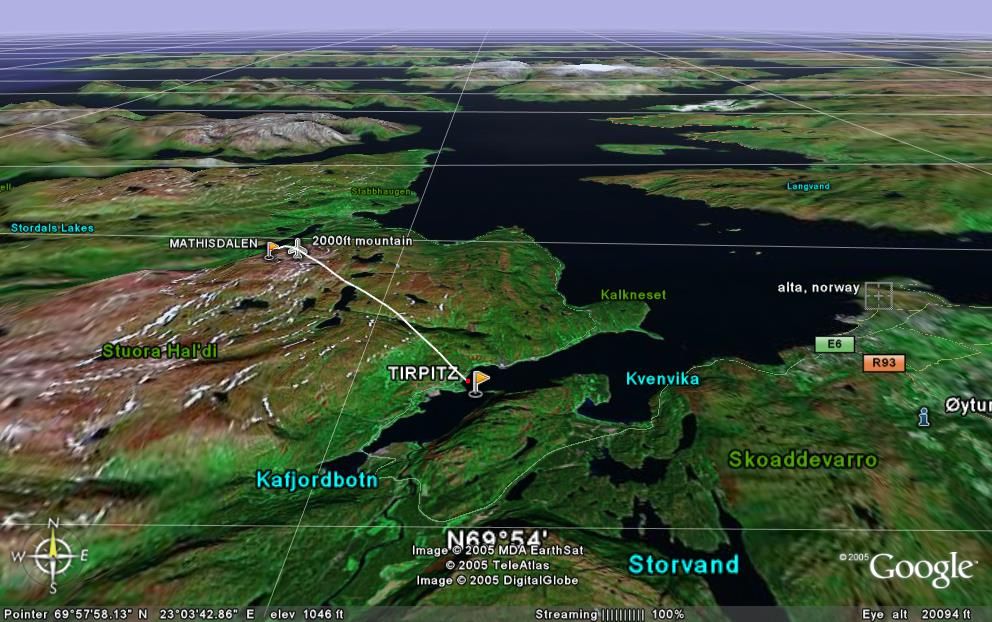
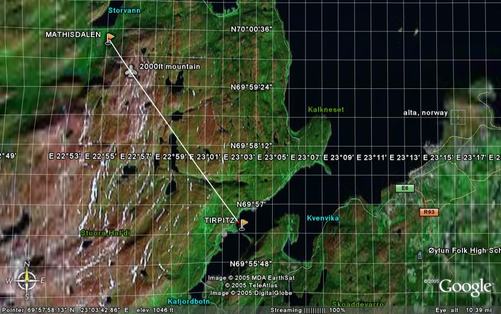
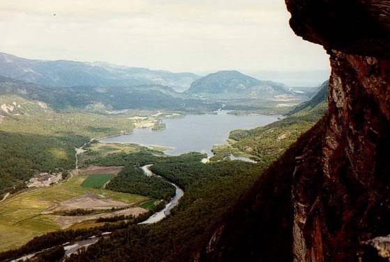 Mathisdalen (Mathis Valley, Norway)
A "pseudo-flight" from Mathisdalen to the "Tirpitz" using Google Earth would look like this (start with the bottom picture). The maps up there in the middle of nowhere have not the details of some sections like New York City and Venice, but it gives you a rough idea. Mathisdalen (Valley) is not even on the map (22.9E/69.85N)! Using it yourself instead of looking at these static pictures is a little more interesting.
Mathisdalen (Mathis Valley, Norway)Ulrich

Re: AltaFjord, KaaFjord and LangFjord
Hello All,
I just discovered this website. My congratulations and thanks to all.
Does anyone know how many and what types (88mm/105mm?) of cannons were in the 10 flak batteries (710 Marine Flak Abt) surrounding Kaafjord?
Also, how many and what types of support ships would be present at the anchorage? How many VP's? Other ships?
Any and all details would be greatly appreciated.
Thanks
Rand
Re: AltaFjord, KaaFjord and LangFjord
Great thread, as are all the Fjord related ones. Having just received a Soldbuch to a member of the Flak ship 'Thetis' it has a handful of photos and I was wondering if anyone can confirm the location. Unfortunately it has no writing on the back but the mountain in the background seems to bear a resemblance of the mountain shown in the photos of Tirpitz at LangFjordBotn.
Do the comparisons match the mountain profile?
Do the comparisons match the mountain profile?
- Attachments
-
- sh-langfjord002.jpg (81.12 KiB) Viewed 8756 times
Re: AltaFjord, KaaFjord and LangFjord
Thetis image:
- Kevin
- Kevin