Hello everybody,
regarding the north maps reference, it is my assumption that they were using the geographical north they had on their maps.
But if the difference among the 3 type of north and probably on the type of maps used has been a crucial factor on the night of the 23rd for the Suffolk, it is not a problem in this situation on this battlefield area.
The parallel 63°N has a width of 27,23 sea miles and after 60 sea miles to north, the parallel 64°N does have a width of 26,30 sea miles, so the total difference on the map is 0,93 sea miles to be distributed on 60 sea miles lenght of the 2 quadrants involved, longitude 31 to 33 West.
This brings out the problem of the tolerances, and as said several times we need to take in account the tolerance factor anyhow.
I see that you Bill Jurens do have a lot of competences about it, and I like you to determine in this case which type of tolerances can be considered acceptable on this type of reconstruction work, both for your competences as well as for your new role I think that everybody will be ok about it.
In this regard, I see your example about the bearing tolerance and I agree about it.
Still it is my opinion that the bearings are the most accurate parameter we have on this battle because as we should have realized the estimated distances between the warships involved were a lot incorrect because of several reasons especially at open fire or at interception where the distances were greater.
Usually the distances at the end of the analysis will result a lot shorter.
So we need a set of tolerances for the bearing, for the distance, for the timing, for the speed and the course.
For example :
Bearing : +/- 1 degree from the given angle.
Distance : +/- 1.000 yards every 10 sea miles
Timing : +/- 1 minute for the given minute
Speed : +/- 1 knot for the given speed
Course >: +/- 3 degrees for the given course
The above is just my personal suggestion.
Bye Antonio
Bismarck at DS after the second turn
Moderator: Bill Jurens
-
Antonio Bonomi

- Senior Member
- Posts: 3799
- Joined: Mon Oct 18, 2004 10:44 am
- Location: Vimercate ( Milano ) - Italy
Re: Bismarck at DS after the second turn
Last edited by Antonio Bonomi on Sun Nov 18, 2018 9:09 am, edited 1 time in total.
In order to honor a soldier, we have to tell the truth about what happened over there. The whole, hard, cold truth. And until we do that, we dishonor her and every soldier who died, who gave their life for their country. ( Courage Under Fire )
-
Alberto Virtuani

- Senior Member
- Posts: 3605
- Joined: Mon Jul 08, 2013 8:22 am
- Location: Milan (Italy)
Re: Bismarck at DS after the second turn
Hello everybody,
while all the above considerations about uncertainties in the measurements are correct, I think we are here trying to reconstruct the relative position of each ship, using their cross-bearings and available tracks, while we are not much interested at absolute positions. The only absolute position was assumed by Antonio in his reconstruction as the point of Hood explosion being the one where the wreck was found. This is an assumption, as the ship may have traveled underwater somehow while sinking, but this absolute position is used only as starting point without any pretense of being 100% exact.
The relative positions of the ships, on the other hand, may be subject to small errors, but when they match perfectly between German and British records, then it means just they are precise enough to be used without problems, and taken with the same reference to the same North. We are very lucky in this case, having both sides observations and I think we can apply some tolerances to the ones that are not cross-checked only.
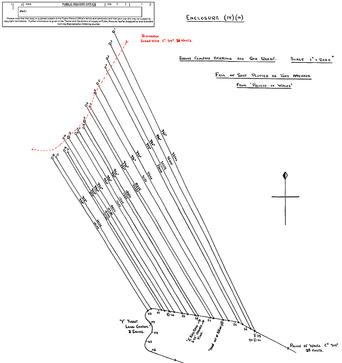
Putting together PG track (from her battlemap) and PoW track (from Pow maps + PoW salvo plot) at 6:00 can be done quite lightheartedly, as we have both German and British bearings to the enemy (http://www.hmshood.com/history/denmarks ... tlemap.gif , http://www.hmshood.com/history/denmarks ... encIVb.gif) and they match by less than 2 degrees difference, thus with a max error at 15 km of 500 meters. The Hood position relative to PoW is exactly known (see from here the Diagram A http://www.hmshood.org.uk/reference/off ... 1_to59.htm), as it is Bismarck position relative to PG (from photo NH69722, in keel line with PG at around 5:55), and her distance from enemy, thus her relative course (from PoW salvo plot from 5:55 till 6:00 http://www.hmshood.org.uk/reference/off ... encIVa.gif).
Bye, Alberto
while all the above considerations about uncertainties in the measurements are correct, I think we are here trying to reconstruct the relative position of each ship, using their cross-bearings and available tracks, while we are not much interested at absolute positions. The only absolute position was assumed by Antonio in his reconstruction as the point of Hood explosion being the one where the wreck was found. This is an assumption, as the ship may have traveled underwater somehow while sinking, but this absolute position is used only as starting point without any pretense of being 100% exact.
The relative positions of the ships, on the other hand, may be subject to small errors, but when they match perfectly between German and British records, then it means just they are precise enough to be used without problems, and taken with the same reference to the same North. We are very lucky in this case, having both sides observations and I think we can apply some tolerances to the ones that are not cross-checked only.
Putting together PG track (from her battlemap) and PoW track (from Pow maps + PoW salvo plot) at 6:00 can be done quite lightheartedly, as we have both German and British bearings to the enemy (http://www.hmshood.com/history/denmarks ... tlemap.gif , http://www.hmshood.com/history/denmarks ... encIVb.gif) and they match by less than 2 degrees difference, thus with a max error at 15 km of 500 meters. The Hood position relative to PoW is exactly known (see from here the Diagram A http://www.hmshood.org.uk/reference/off ... 1_to59.htm), as it is Bismarck position relative to PG (from photo NH69722, in keel line with PG at around 5:55), and her distance from enemy, thus her relative course (from PoW salvo plot from 5:55 till 6:00 http://www.hmshood.org.uk/reference/off ... encIVa.gif).
Bye, Alberto
"It takes three years to build a ship; it takes three centuries to build a tradition" (Adm.A.B.Cunningham)
"There's always a danger running in the enemy at close range" (Adm.W.F.Wake-Walker)
"There's always a danger running in the enemy at close range" (Adm.W.F.Wake-Walker)

Re: Bismarck at DS after the second turn
Hello All,
It has been observed:
None of this has any supporting evidence. We are currently dealing systematically with actual documents, not interpretations made decades later of when photographs were taken, whose times are unrecorded. I respectfully suggest that can wait.
Antonio's identification of a consistent 4.1 km over-estimate of range in the German map and sketch documentation is significant. As is his belief that an improved and more accurate Gefechtsskizze remains to be discovered. Can we not attempt to derive a reason why these consistently-erroneous values exist on the mapped German records of the event?
The very fact that Reimann maps with a consistent error does not invalidate his PoW course estimate.
As for the unqualified acceptance of PoW's track we already know the timings are subject to question, and neither the salvo plot not the other plan show the sharp turn towards the enemy observed and noted by both British and German observers and clearly delineated by Reimann's sketch where the absolute range values may be in consistent error for an unknown reason, but the relative change may be correct.
All the best
wadinga
It has been observed:
as it is Bismarck position relative to PG (from photo NH69722, in keel line with PG at around 5:55), and her distance from enemy, thus her relative course (from PoW salvo plot from 5:55 till 6:00
None of this has any supporting evidence. We are currently dealing systematically with actual documents, not interpretations made decades later of when photographs were taken, whose times are unrecorded. I respectfully suggest that can wait.
Antonio's identification of a consistent 4.1 km over-estimate of range in the German map and sketch documentation is significant. As is his belief that an improved and more accurate Gefechtsskizze remains to be discovered. Can we not attempt to derive a reason why these consistently-erroneous values exist on the mapped German records of the event?
To realize why Reimann drew that PoW track is enough to read his report where he explained that he was realizing just the opposite of what Jasper was realizing as far as what PoW was doing, and we can see the result on his sketch. Jasper was correct as we all know and Reimann was consequently incorrect as we can easily see on his torpedo map.
Anyway, both Reimann as well as Brinkmann drew a very bad enemy track.
The very fact that Reimann maps with a consistent error does not invalidate his PoW course estimate.
As for the unqualified acceptance of PoW's track we already know the timings are subject to question, and neither the salvo plot not the other plan show the sharp turn towards the enemy observed and noted by both British and German observers and clearly delineated by Reimann's sketch where the absolute range values may be in consistent error for an unknown reason, but the relative change may be correct.
All the best
wadinga
"There seems to be something wrong with our bloody ships today!"
-
Antonio Bonomi
- Senior Member
- Posts: 3799
- Joined: Mon Oct 18, 2004 10:44 am
- Location: Vimercate ( Milano ) - Italy
Re: Bismarck at DS after the second turn
Hello everybody,
I do not think that the photo NH 69722 ( Bismarck and Prinz Eugen open fire ) can be now discussed, after we have analyzed it for at least 15 years by now on the own dedicated threads.
Anyway, the fact that Bismarck was following the Prinz Eugen is clearly written in Paul Schmalenbach report at the German alam time at 05:45.
Bismarck was still following the Prinz Eugen when the BC1 warships opened fire at 05:52-05:53 ( McMullen and Skipwith ).
German documents ( ref. previous post on this thread ) confirmed she was in line of battle following the Prinz Eugen at open fire by the Germans at 05:55 and after during the engagement early stage until the torpedo alarm, and the Prinz Eugen until 06:03 was sailing a 220° course.
F.O. Busch on his book confirmed this too.
Wake-Walker confirmed on his report that the Bismarck was following the cruiser; the plot confirms this too.
Norfolk and Suffolk course on the plot shows an average 220° course following and shadowing the enemy.
The PoW salvo plot shows a course of average 220°, with a first part on 210° and a second of 225° before the turn away to starboard at 06:03 ( ref. Capt Leach report ).
I really do not see what else we need to realize about the Bismarck following the Prinz Eugen on course 220° until 06:03 that morning.
Moving on the Reimann map, I have dedicated a thread about this occurrence where all the various documents do explain how and why Reimann made those evaluation errors.
viewtopic.php?f=1&t=8285
In particular Brinkmann explained :
Consequently once those have been translated on his own map, created an incorrect PoW track as obvious.
Again, just as Bill Jurens suggested, it is better and more reliable to use German maps for the German ship tracks and British maps for the British ship tracks.
Bye Antonio
I do not think that the photo NH 69722 ( Bismarck and Prinz Eugen open fire ) can be now discussed, after we have analyzed it for at least 15 years by now on the own dedicated threads.
Anyway, the fact that Bismarck was following the Prinz Eugen is clearly written in Paul Schmalenbach report at the German alam time at 05:45.
Bismarck was still following the Prinz Eugen when the BC1 warships opened fire at 05:52-05:53 ( McMullen and Skipwith ).
German documents ( ref. previous post on this thread ) confirmed she was in line of battle following the Prinz Eugen at open fire by the Germans at 05:55 and after during the engagement early stage until the torpedo alarm, and the Prinz Eugen until 06:03 was sailing a 220° course.
F.O. Busch on his book confirmed this too.
Wake-Walker confirmed on his report that the Bismarck was following the cruiser; the plot confirms this too.
Norfolk and Suffolk course on the plot shows an average 220° course following and shadowing the enemy.
The PoW salvo plot shows a course of average 220°, with a first part on 210° and a second of 225° before the turn away to starboard at 06:03 ( ref. Capt Leach report ).
I really do not see what else we need to realize about the Bismarck following the Prinz Eugen on course 220° until 06:03 that morning.
Moving on the Reimann map, I have dedicated a thread about this occurrence where all the various documents do explain how and why Reimann made those evaluation errors.
viewtopic.php?f=1&t=8285
In particular Brinkmann explained :
The fact that Reimann optical observations resulted being an error is clearly stated by Brinkmann.The errors of observation by optical range finding measurements and in the various reports of turning to or breaking away by the "Prince of Wales" are also pointed out in the artillery report of "Prinz Eugen" B. Nr. G 2243 of 12.7.1941 ( only sent to the Commander of Cruisers ).
There, as with the torpedo weapon's false observations resulted in erroneous actions.
The necessary lessons have been learned.
The torpedo weapon must receive its own rangefinder instruments.
A comparison with the artillery measurements may always be possible, when the target is the same.
Consequently once those have been translated on his own map, created an incorrect PoW track as obvious.
Again, just as Bill Jurens suggested, it is better and more reliable to use German maps for the German ship tracks and British maps for the British ship tracks.
Bye Antonio
In order to honor a soldier, we have to tell the truth about what happened over there. The whole, hard, cold truth. And until we do that, we dishonor her and every soldier who died, who gave their life for their country. ( Courage Under Fire )
-
Alberto Virtuani
- Senior Member
- Posts: 3605
- Joined: Mon Jul 08, 2013 8:22 am
- Location: Milan (Italy)
Re: Bismarck at DS after the second turn
Hello everybody,
Bye, Alberto
Having said so several times, I do agree. Can we consider there is full consensus now about this obvious point and move forward ?Antonio Bonomi wrote: "Again, just as Bill Jurens suggested, it is better and more reliable to use German maps for the German ship tracks and British maps for the British ship tracks"."
Bye, Alberto
"It takes three years to build a ship; it takes three centuries to build a tradition" (Adm.A.B.Cunningham)
"There's always a danger running in the enemy at close range" (Adm.W.F.Wake-Walker)
"There's always a danger running in the enemy at close range" (Adm.W.F.Wake-Walker)
Re: Bismarck at DS after the second turn
Some comments on this: I'm not quite sure why the lengths of the parallels are brought in here. The issue with north references is the following: Any bearing (a direction) is relative to another distinguished direction. Usually this distinguished direction is the direction towards north.Antonio Bonomi wrote: ↑Sun Nov 18, 2018 9:07 am Hello everybody,
regarding the north maps reference, it is my assumption that they were using the geographical north they had on their maps.
But if the difference among the 3 type of north and probably on the type of maps used has been a crucial factor on the night of the 23rd for the Suffolk, it is not a problem in this situation on this battlefield area.
The parallel 63°N has a width of 27,23 sea miles and after 60 sea miles to north, the parallel 64°N does have a width of 26,30 sea miles, so the total difference on the map is 0,93 sea miles to be distributed on 60 sea miles lenght of the 2 quadrants involved, longitude 31 to 33 West.
This brings out the problem of the tolerances, and as said several times we need to take in account the tolerance factor anyhow.
Now at any location, there are three types of north:
1) Geographic North - the direction towards the piercing point of the rotational axis of the earth with the surface (=geographic north pole).
2) Magnetic North - the direction towards the magnetic north pole, that is where the magnetic field lines enter the earth's surface with angle angle of 90 degrees. For example, a bearing relative to the magnetic north pole differs by 33 degrees from a bearing relative to the geographic north pole (for the location Denmark Strait in May 1941; https://www.ngdc.noaa.gov/geomag-web/#declination). However, I think this is irrelevant here as I would be very surprised if any nautical bearing in this case refers to magnetic north.
3) Grid north: This is the vertical axis (or just the left or right edge) on a map. A map is a projection which converts the spherical/elliptical coordinates (latitude, longitude) to rectangular/cartesian coordinates. A map projection always comes with distortion - this means an angle measured at the sphere/in the field (like a bearing) will be transformed to a different angle in the map. Depending on the map projection and where you are, this angle difference can be anywhere between 0 and tens of degrees. This is important if you use raw bearings and draw them on a map (or any piece of paper where you assume that you have cartesian metrics).
Now for the DS, I think it is most likely that raw bearings with reference to geographic north are used. However, as pointed out by Bill Jurens, can we be sure f that? E.g. do we know that the bearings (towards other ships) are referenced to north, and not to the own ship's course?
I also have to comment on tolerances and relative vs. absolute: I understand that the procedure is to establish the courses of PG and POW from their own maps, and in a later stage, try to draw them on one common map. Now for this second part of the exercise, of course we need to have one common reference frame, which is the same like an absolute reference frame. It does not matter where in space this frame is tied to (e.g. if the location of the sinking of the Hood is (0,0) or some (longitude, latitude), but nonetheless we must have tied all or observations to one absolute frame (e.g. knowing what the bearings represent).
Tolerances: This is also much more complicated. While the actual observer's reading accuracy maybe is one degree (or even less, with good visibility), the (required) accuracy depends also on the instrument. The geographical bearings are taken from gyrocompasses. A gyrocompass needs to be calibrated as often as possible, which in turn requires exact locations (astronomical fixes) and speeds etc. The calibration of a gyrocompass will suffer if the compass is moved S-N and if the speed/course of the platform changes. Now I don't have any exact numbers on that for 1941 compasses - we would need a nautical/technical historian. But from a gut feeling and some experience, I would be much more conservative and assume at least 5 degrees accuracy for a bearing. A further complication is systematic vs. random error: Now an observer's reading is regarded as a random error (e.g. can be positive or negative), but a missing calibration is a systematic error (will be always wrong in the same direction). If bearing readings from several ships are involved, it is safe to assume that each calibration will be different. So the final error estimation is much more complicated, but of course the final error (estimated accuracy) is much larger.
So I would suggest:
1) Clarification/confirmation what types of bearings are used
2) Agreement on error specs for bearings (and for all other observations such as ranges and times)
-
Bill Jurens
- Moderator
- Posts: 878
- Joined: Mon Oct 18, 2004 4:21 am
- Location: USA
Re: Bismarck at DS after the second turn
I think we are making good progress here. Discussing some of the potential mechanical issues early on, e.g. establishing what we think are reasonable allowances for errors of observation, etc., is well worth while, and at least puts all (or most) of us on the same page.
I would agree that in practical terms True North is always True North. I think some confusion may revolve around the newer concept of 'Grid North', which makes reference to the Universal Transverse Mercator Grid -- hereafter the UTM grid -- which had not really been invented in 1940 or so, and was not in really wide use until after 1945. Many topographic maps now contain what amounts to two references to "north", the first being the traditional True North, and the second referring to UTM grid north, which is often canted up to about 5 degrees with respect to True North. This is a function of the map projection process, which is not really applicable to charts made prior to 1950 or so. Some maps actually now contain three versions of north, i.e. true north and -- because the UTM zones overlap a bit, UTM Zone "x" North, and UTM Zone "y" North.
It is also possible that what Northcape, and perhaps some others, may have been concerned about is the phenomena revolving around the so-called 'convergence of the Meridians'. This essentially means that two ships at different longitudes, each travelling directly north, will not really be on parallel paths -- they will eventually collide at the pole. In practical terms, this aspect of the problem, which really involves dipping one's toes into spherical trigonometry, is usually (and properly) ignored. It's related to the concept referred to in surveying as 'spherical excess'.
Although I am right now very busy completing some other project work, I do hope to be able to invest more time in the Denmark Strait discussions after the New Year, perhaps even earlier. One approach, which is somewhat time consuming, is to reduce all of the original track charts to a constant scale and in effect superimpose them upon one another until the best overall geometric match is obtained. I did this many years ago when I first drew track charts of the action for publication. I revisited, but did not entirely repeat that process when constructing the Denmark Strait chart for the upcoming book. My overall reconstruction represented what seemed to best overall 'fit' the four or five original reference documents, plus other reconstructions published in various and sundry secondary sources after the war, with emphasis placed on the official maps first.
Hope this helps...
Bill Jurens
Re: Bismarck at DS after the second turn
Strictly speaking, the true vs. grid north exists for all projections, since the grid north always is parallel to the vertical edge of the map. However, if I am not mistaken the large-scale nautical charts were mostly gnonomical projections where meridians plot as straight lines, do. the true north direction is directly readable from the map (but very different from the vertical edge of the map).
But I understand now that this is largely an academic discussion, and what I take away is the following: it is assumed that all the original small-scale battlemaps have no projection at all, but they are simply oriented to true (geographic) north, and the plotted tracks are metric distances calculated from speeds and course changes only. With this dead reckoning (no astronomical fixes), it is obvious that errors or inaccuracy in speed, course, or time measurements at any time will sum up. So it really would be required to have an exact log of these measurements, and an idea about their accuracies. Only then one could judge the reliability of any original map.
I apologize for being picky, but if you start to talk about location estimates in the range of several hundreds of meters than this should not be neglected.
-
Antonio Bonomi
- Senior Member
- Posts: 3799
- Joined: Mon Oct 18, 2004 10:44 am
- Location: Vimercate ( Milano ) - Italy
Re: Bismarck at DS after the second turn
Hello everybody,
interesting discussion that applies a lot on the 23rd night shadowing effort by the Suffolk.
Here I think we can assume we have just one north, the one on the available maps.
At this point we should be OK with the 4 main warships position at 06:00 ( common reference point ) with my above modified Rowell map once the Prinz Eugen position is added to it.
Similarly we should be OK with the Bismarck run track on course 220° following the Prinz Eugen in line of battle from 05:45 ( alarm ) until 06:03 ( turn to starboard due to PG torpedo alarm ).
The Hood run track is easy to be defined once the PoW track is realized merging the many maps we have of her ( there are some differences among them ).
The available bearings among the warships between 05:37 and 06:03 will simply confirm the convergence among the squadrons.
Any disagreement about the above ? If so, why and based on what ?
Bye Antonio
In order to honor a soldier, we have to tell the truth about what happened over there. The whole, hard, cold truth. And until we do that, we dishonor her and every soldier who died, who gave their life for their country. ( Courage Under Fire )
Re: Bismarck at DS after the second turn
Hello Antonio,
I believe the dedicated thread on Reimann's failure to launch torpedoes was sidetracked and reached no sensible conclusions about why he recorded a series of ranges apparently consistently, as identified by you, as being 4100m over the real range. My reading of the PG KTB does not identify
Various experts have talked about the data transfer systems of this era, (magslip synchro etc) and Reimann appears to have received a range value 4100m too high. For reasons which are completely unclear, the Gefechtsskizze has exactly the same problem. Why draw a battle sketch based on details from a non-occurring torpedo attack instead of the successful gunnery effort? Since Jasper was having gunnery success he was not receiving the same erroneous values. But there nothing to suggest that it was not the same data, but without a fixed error induced by the transmission system.
Therefore Reimann's sketch which has more data points than those isolated observations by Jasper may provide an excellent map of PoW's movements, simply 4100m too far away from PG.
Brinkmann "At the time when the Prince of Wales turned hard towards the German formation between 05:01 and 05:02 hours I estimated I estimated that an opportunity for a torpedo launch had arrived.
Reimann "The turning towards us by the opponent was first observed by the observation tower and shortly thereafter verified by the bearing taker in the computing station.
Since this turn is not represented on either of the British maps, they represent a poor estimate of the British course.
This systematic evaluation of the maps is barely started, what is the rush to "Move on" I wonder?
All the best
I believe the dedicated thread on Reimann's failure to launch torpedoes was sidetracked and reached no sensible conclusions about why he recorded a series of ranges apparently consistently, as identified by you, as being 4100m over the real range. My reading of the PG KTB does not identify
What I gather is that the range information was being sent from the same rangefinders as Jasper was using, and it is nowhere clear why having a dedicated rangefinder would have given superior information. The gunnery solution was using information combined from the long baseline rangefinders and the radar. There was only one target, PoW. Reimann's computer had to use this same current range information with an estimate of inclination to derive a firing direction with a huge lead angle in order to get intersection with PoW's predicted future position in 20-25 minutes' time, when the torpedoes got there. With such a long lead time and PoW's heading swinging wildly about it was impossible to be sure PG's torpedoes would be wasted on a solution that existed for only seconds. Which is what Reimann said.The fact that Reimann optical observations resulted being an error is clearly stated by Brinkmann.
Various experts have talked about the data transfer systems of this era, (magslip synchro etc) and Reimann appears to have received a range value 4100m too high. For reasons which are completely unclear, the Gefechtsskizze has exactly the same problem. Why draw a battle sketch based on details from a non-occurring torpedo attack instead of the successful gunnery effort? Since Jasper was having gunnery success he was not receiving the same erroneous values. But there nothing to suggest that it was not the same data, but without a fixed error induced by the transmission system.
Therefore Reimann's sketch which has more data points than those isolated observations by Jasper may provide an excellent map of PoW's movements, simply 4100m too far away from PG.
As for the unqualified acceptance of PoW's track we already know the timings are subject to question, and neither the salvo plot not the other plan show the sharp turn towards the enemy observed and noted by both British and German observers and clearly delineated by Reimann's sketch where the absolute range values may be in consistent error for an unknown reason, but the relative change may be correct.
Brinkmann "At the time when the Prince of Wales turned hard towards the German formation between 05:01 and 05:02 hours I estimated I estimated that an opportunity for a torpedo launch had arrived.
Reimann "The turning towards us by the opponent was first observed by the observation tower and shortly thereafter verified by the bearing taker in the computing station.
Since this turn is not represented on either of the British maps, they represent a poor estimate of the British course.
This systematic evaluation of the maps is barely started, what is the rush to "Move on" I wonder?
All the best
"There seems to be something wrong with our bloody ships today!"
-
Alberto Virtuani
- Senior Member
- Posts: 3605
- Joined: Mon Jul 08, 2013 8:22 am
- Location: Milan (Italy)
Re: Bismarck at DS after the second turn
Hello everybody,
The fact that the corrective action after the operation was the installation of a dedicated rangefinder, points to the fact that, during the battle, Reimann had no access to real-time range data from Jasper/TS.
Anyway, Brinkmann is clear saying that Reimann estimation of the distances and of the shape of PoW track after Hood explosion is simply wrong.
Bye, Alberto
Source please ?Wadinga wrote: "What I gather is that the range information was being sent from the same rangefinders as Jasper was using"
The fact that the corrective action after the operation was the installation of a dedicated rangefinder, points to the fact that, during the battle, Reimann had no access to real-time range data from Jasper/TS.
Anyway, Brinkmann is clear saying that Reimann estimation of the distances and of the shape of PoW track after Hood explosion is simply wrong.
Bye, Alberto
"It takes three years to build a ship; it takes three centuries to build a tradition" (Adm.A.B.Cunningham)
"There's always a danger running in the enemy at close range" (Adm.W.F.Wake-Walker)
"There's always a danger running in the enemy at close range" (Adm.W.F.Wake-Walker)
Re: Bismarck at DS after the second turn
.
Re. bearings, there might be a bit too much optimism being expressed as +/- 1-degree.
Yes, when a bearing is taken by the director control tower, or plinth mounted high powered binoculars that is possible, however, for ordinary binocular lookouts I think that is rather optimistic.
.
Re. bearings, there might be a bit too much optimism being expressed as +/- 1-degree.
Yes, when a bearing is taken by the director control tower, or plinth mounted high powered binoculars that is possible, however, for ordinary binocular lookouts I think that is rather optimistic.
.
Re: Bismarck at DS after the second turn
The optical reading accuracy is just one part. I still think that +/- 1 deg is feasible for reading (depending on the optical instrument).
However, I also still think that the limited calibration of the instrument introduces a much higher inaccuracy such that the effective bearing tolerance is much higher as well. But it would need someone with knowledge on gyrcompass operation in the 1940ies to put an exact number.
However, I also still think that the limited calibration of the instrument introduces a much higher inaccuracy such that the effective bearing tolerance is much higher as well. But it would need someone with knowledge on gyrcompass operation in the 1940ies to put an exact number.
-
Antonio Bonomi
- Senior Member
- Posts: 3799
- Joined: Mon Oct 18, 2004 10:44 am
- Location: Vimercate ( Milano ) - Italy
Re: Bismarck at DS after the second turn
Hello everybody,
having defined the 06:00 bearings among the 4 main warships, the utilization of the Prinz Eugen and PoW own tracks as base reference, and having positioned correctly the Hood track, back we are here with the Bismarck track re-construction following my 2005 work based on the available evidence :
viewtopic.php?f=1&t=8335#p81065
Everyone can check the 06:00 base reference bearings and the PoW gunnery plot bearings from 05:52 until 06:03 toward the Bismarck and everything will be ok.
Any disagreement ?
Bye Antonio
In order to honor a soldier, we have to tell the truth about what happened over there. The whole, hard, cold truth. And until we do that, we dishonor her and every soldier who died, who gave their life for their country. ( Courage Under Fire )
Re: Bismarck at DS after the second turn
Hello Alberto,
You have said:
PG KTB Page 87, last paragraph of Reimann's report.
Brinkmann confirms Reimann's sketch by describing PoW turning hard towards PG and uses the same values as Reimann for his own Gefechtsskizze. As we have established Reimann has no rangefinder so cannot have an "estimation of the distances" and cannot be criticized over them. His only error was believing what the main rangefinding system was telling him and with no other information how was he to know?
Interestingly Brinkmann says on Page 88 of the KTB
The unreliability of PoW's own tracks have been clearly shown by Reimann's sketch based on the PG's combined ranging systems (with fixed offset) and the observations of numerous witnesses, both British and German. Consequently I disagree with Antonio's observation that everything is OK.
All the best
wadinga
You have said:
Reimann clearly says he got his range data from the main system.Wadinga wrote: "What I gather is that the range information was being sent from the same rangefinders as Jasper was using"
Source please ?
The fact that the corrective action after the operation was the installation of a dedicated rangefinder, points to the fact that, during the battle, Reimann had no access to real-time range data from Jasper/TS.
Anyway, Brinkmann is clear saying that Reimann estimation of the distances and of the shape of PoW track after Hood explosion is simply wrong.
PG KTB Page 87, last paragraph of Reimann's report.
Why? Because Reimann wants his own independent system to gross error check the values he is receiving since a transmission error here has given him values consistently 4100m too high. Obviously the combined rationalized output of several 7m instruments plus the radar will be vastly superior to the single 3m night rangefinder (already installed) he suggests using as back-up, but values from which would at least detect transmission errors plus the off chance his target is different to the one the artillery are shooting at.Despite the switching that delivers the parallel values of the entire rangefinding system to the artillery and torpedo weapons, this battle demonstrates a sharp separation between artillery and torpedo rangefinding systems must exist.
Brinkmann confirms Reimann's sketch by describing PoW turning hard towards PG and uses the same values as Reimann for his own Gefechtsskizze. As we have established Reimann has no rangefinder so cannot have an "estimation of the distances" and cannot be criticized over them. His only error was believing what the main rangefinding system was telling him and with no other information how was he to know?
Interestingly Brinkmann says on Page 88 of the KTB
This makes little sense as PG was hitting PoW at the end of the engagement anyway. Where are these errors? Has anyone seen this report G 2243? It presumably has much more detail than the sketchy fragments of Jasper narrative included in the KTB. It must be G 2243 which is supposed to supply the superior values Brinkmann is instructed to use in the rewritten KTB he is supposed to submit.The errors of observation by optical range finding measurements and in the various reports of turning to or breaking away by the PoW are also pointed out in the artillery report of Prinz Eugen B Nr G 2243 of 12.7.41 (only sent to Commander of Cruisers). There, as with the torpedo weapon's false observations resulted in erroneous actions.
The unreliability of PoW's own tracks have been clearly shown by Reimann's sketch based on the PG's combined ranging systems (with fixed offset) and the observations of numerous witnesses, both British and German. Consequently I disagree with Antonio's observation that everything is OK.
All the best
wadinga
"There seems to be something wrong with our bloody ships today!"